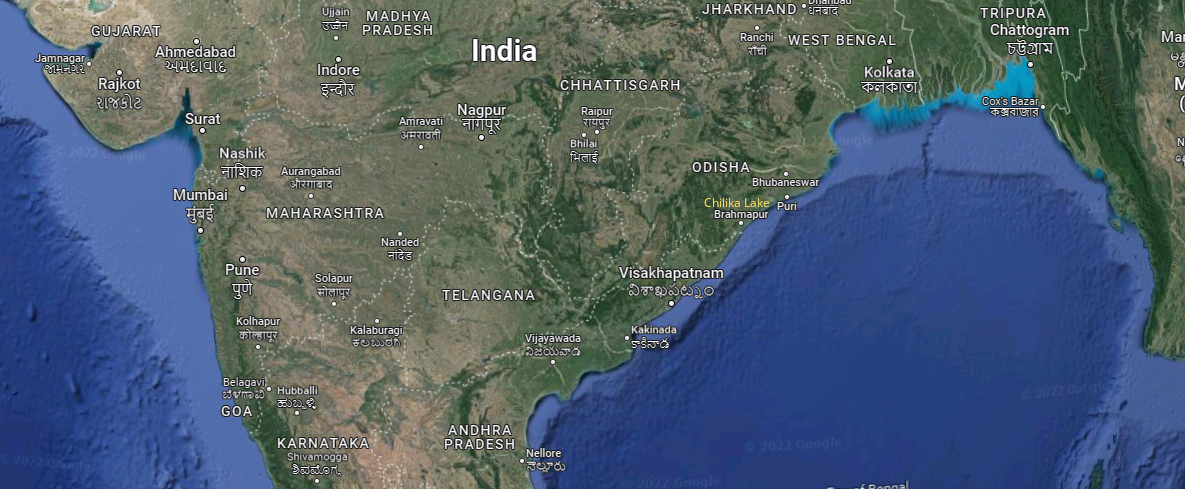
Project area. The Chilika Lake is situated between Brahmapur and Puri, almost in the middle.
To get a better understanding of the shared history of the VOC and India, some background information on the project area and its topography might be helpful.
Kalinga, from Buddism to Hinduism
Basically, our area covers the Indian East coast from the north of Andhra Pradesh, all along the coast of Odisha, up to the Houghly river in West Bengal. If there is one thing that the various sections of this vast stretch of land and water have in common, it is their having been part of Kalinga. Kalinga, a Buddhist empire, was founded by Ashoka the Great, emperor of the Mauriya dynasty. He was born at Patna, Bihar, in 304 BC, spread his empire over most of the subcontinent, and ruled it from 268 – 232 BC. Ptolemaeus, the famous Greek scientist and geographer of those days, – and by the way, the first one who claimed our planet was round,- called the sea along this coast the Sea of Kalinga. Only much later the British renamed this sea the Bay of Bengal.
Because of the growth of Hinduism, the decrease of the number of Buddhist universities, and the Islamic invasions from the North-West, Buddhism went down and nearly disappeared from its country of birth by the 12th century AD, while spreading to other parts of Asia. But its physical heritage is spread throughout our project area, and remains of it are still re-discovered. Initially, the capital of Kalinga was established at Jaugada, a fortress by the Rushikuliya river in Ganjam, Odisha.
Our project area divided in four
Our project area may be divided into four parts. The coast of Odisha is split in two by the Chhilka Lake. This huge lagoon harbours millions of migratory birds, is annually visited by olive ridley tortoises, and is considered the home of the bottlenose dolphin. The lagoon is covered by three districts of Odisha: Ganjam to the south, Khurda to the west, and Puri to the north. The VOC had settlements in all three districts, but only in Ganjam a Dutch physical structure still exist.
Here come the Dutch
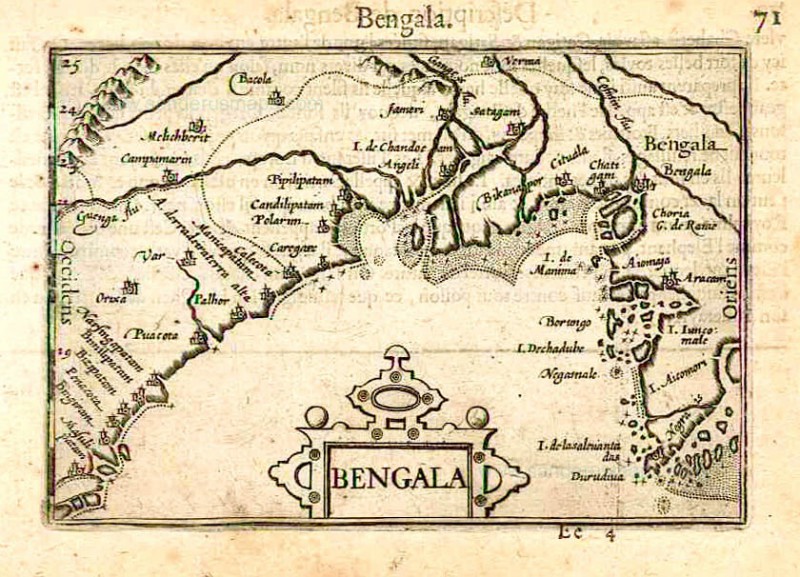
The first reliable Dutch map of Orixa, as it was called, was made in 1596 by the explorer and seafarer Berendt Langenes from Middelburgh, Zeeland (1). He was part of the first fleet organized to the East by Adriaen Hendricks Ten Haeff by the the Shipping Company of Faraway at Middelburgh, from 1595 to 1604 (2).
Probably the East coast south of Ganjam, now situated in the bordering state of Andhra Pradesh, was the most fertile part of the coast. Traders called it the Gingelly Coast, after the sesame seeds and oil they could buy there. Politically and socially, life was and is quite different there from the north. Both Ganjam and Srikakulam, the adjoining and most northern, district of (now) Andhra Pradesh, were part of the kingdom of Golkonda, ruled by the Quli Shahs. The Quli Shahs were a Shia dynasty, who were in favour of sharing with Hindus. Secondly, the most common language in Srikakulam (called Cicagole in those days), was Telugu, a south-Indian language, while Odia was a North Indian language.
Before 1600, the coast of Odisha north of Chhilka Lake was dominated by the Afghan rulers from Bengal. After that, the Moghuls from Agra and their officers took over from the Afghans. It should be noted that the sheer majority of the population were Odia-speaking Hindus in the coastal area, and tribals in the inland hills, most tribes speaking separate languages. Odisha as a whole was divided in a large number of separate kingdoms as well.
Finally: the east coast begins from, or ends with, the delta of the Ganges, where land and water were, and mostly still are, in a dynamic state of balance with each other, and where sailing was dangerous. The mangroves of the Sunderbans. To know more about these mangroves, one may read the fascinating novel “The hungry tide” by Nobel-prize winner Amitav Ghosh (2004). The wealth of Bengal, which attracted so many foreigners and was praised extensively (though recognizing its political complexity) by travelers such as the Dutch inspector Jacob Mahieusen (3), was to be harvested in the adjoining parts of the North.
Now, the history of the VOC in our project area is summarized, in two parts, i.e. north and south of the Chhilka Lake.
Footnotes
1 Das Mohapatra, Lalatendu: Commerce in Orissa 1600 – 1800, p. 21. Prafulla: Kolkata, 2010.
2 Mollema, J.C.: De eerste schipvaart der Hollanders naar Eest-Indië, 1595 – 1597. Martinus Nijhoff 1936′ ‘s Gravenhage, tweede uitgave.
3 Mathieusen, Jacob (1641): Rapport over zijne reis met den retourvloot, 1641. Utrecht, Archief van Hilten, pp. 340-350 (translation forthcoming).